
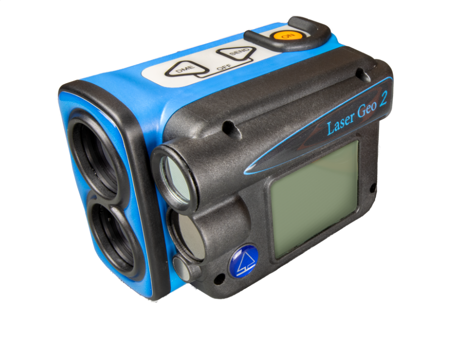
HAGLOF Laser Geo 2 Handheld Laser Rangefinder (0-999 m/ft)
Size: 93x63x72mm/3.7×2.5×2.8”
Weight: 243 g/8.6oz.
Battery and consumption
Rechargeable Li-Ion 3.7V, built-in, approx. 2000 measurements. Charging time max 3.5h.
USB mini B interface wall charger 110/220AC/5VDC; car charger adapter 12VDC. Cable Usb mini B Male/Usb Type A Male, 0.5m.
Consumption max 0.9W.
Communication
IR, USB 2.0/SSD Disk.
Dual-mode Bluetooth BR/EDR.
Bluetooth low energy V4.2 (LE) and Classic connectivity.
Spp (serial profile), pin code 1234.
Temperature: -20° to +45° C/ -4°F-113°F.
Height: 0-999 m/ft. Resolution height: 0.1 m/ft.
Angle: -90° – 90°. Unit: Degrees 360⁰, Grads 400⁰ and %. Resolution: 0.1⁰. Accuracy: 0.1⁰ typical.
LASER
Distance: 46cm/1.5ft – 700m/2000ft depending on target. Accuracy: 4cm/0.1ft typical.
Resolution: 0.1m/ft (0.01m/0.1ft in DME-mode).
Areal
0<area<5000m2 or 0.5ha<area<10000ha
0<area<20000f2 or 0.5acre<area<10000acre
Remote diameter
Sight range: 0-46 positions
Max diameter: 47” at 39ft / 98cm at 10m
Resolution: 0.1”/ 0.1cm
Accuracy : 0.5” at 39ft / 1.2cm at 10m
GPS
33-channel high sensitivity receiver. Supports GPS, Glonass, Galileo, QZSS. Built-in real tme correction w SBAS (EGNOS, WAAS, MSAS, GAGAN)
Accuracy down to 2.5m/8.19ft in open terrain. Satellite position prediction for up to 3 days.
Host Based multi-global navigation satellite system GPS(USA)/GLONASS(Russia)/Galileo(EU)/QZSS(JAPAN) SBAS Satellite-based augmentation systems: WAAS(US) EGNOS(EU) GAGAN (India) MSAS(Japan). Built-in self-generated orbit prediction (Faster TTFF up to 3 days), built-in jamming removing. Accuracy: Automatic position 2.5m CEP (circular error probable) (50% 24 hr static, -130dBm.
Speed 0.1m/s (50%@30m/s.
Compass: Azimuth compass 0-360˚, resolution 0,1˚, accuracy <1.5 RSME˚.
Classification: MIL-STD-810E. Housing frame material glass filled poly carbonate, IP67, NEMA6, Laser class 1, 7mm (FDA, CFR21) Class 1m (IEC 60825-1:2001).
Sight: Dot aim 1 x magnification and (HUD) Head-up-display.
Display: External Graphic LCD 100x60pixles. Internal (HUD) Head-up-display.
Dataformat: Nmea or Ascii. IR, Bluetooth.
File Format: CSV and KML (Google Earth).
Memory: 2000 datasets, non-volatile.
Other information
Adapter and monopod staff, 4-parts (33-140cm)
Aluminum transport/storing case. See user manual for more details.
Get exclusive volume discounts, bulk pricing updates, and new product alerts delivered directly to your inbox.
By subscribing, you agree to our Terms of Service and Privacy Policy.
Direct access to our certified experts